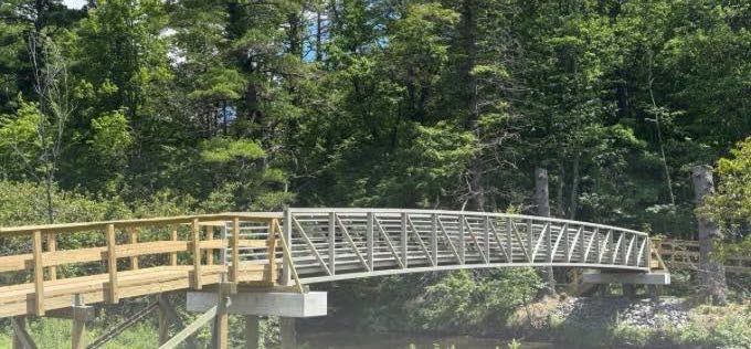
The city of Portland is getting ready to open a pedestrian bridge in the Stroudwater neighborhood that will connect two greenways and provide an opportunity to build future trails.
The ribbon will be cut for Stroudwater Bridge on Sept. 18 at 1:30 p.m. The trailhead path is between 48 and 54 Owls Nest Road off Westbrook Street. The trail leads through a field, thence down a slope to the river’s edge and the bridge.
The event will be hosted by the city, whose parks, recreation and facilities department managed the project, and Portland Trails.
“In 2018, a local developer donated a pedestrian bridge to the city of Portland for use on our trail network,” said Ethan Hipple, the department’s director.
The bridge will allow Portland Trails to accomplish its longtime goal of connecting the Stroudwater River Trail with the Fore River Sanctuary.
The project cost was $370,000. The bridge itself was a donation. The primary project costs were engineering, permitting and construction of abutments, ramps and bridge installation, funded by $120,000 from a Recreational Trails Program grant, $160,000 from City Capital Improvement Funds, $50,000 from Portland Trails and $40,000 from the abutting developer and community fundraising efforts, Hipple told Mainebiz.
Acorn Engineering was the engineer for the project. The city’s Parks, Recreation and Facilities Department led the project and handled the bidding, hiring of the engineer and contractor, and implementation.
Key connector
Construction crews lifted the bridge with a crane and set it into place on Feb. 6. After that, crews built two long ramps on both sides of the bridge that will help connect to future trails. The bridge and ramps were designed accessibly for wheelchair users.
Developers of the adjacent Stroudwater Preserve housing development and Unum Corp. also collaborated on the project.
The bridge paves the way for the future three-mile Stroudwater Connector Route.
“Starting this year, we’re building and improving three miles of trails that will connect the Stroudwater River Trail with the Fore River Sanctuary and beyond,” said Jon Kachmar, Portland Trail’s executive director. “These new and upgraded trails are central to our vision for the Stroudwater Connector Route. This will be a direct, safe and enjoyable off-street transportation route connecting outer Congress Street with Brighton Avenue and Rock Row.”
Users of the Stroudwater Connector Route are expected to include bike commuters and pedestrians.
Stroudwater River Trail
The five-mile, densely wooded Stroudwater River Trail, maintained by Portland Trails, follows the river’s winding banks along the south side, from outer Congress Street to Clark Brook Trail and Smiling Hill Farm in Westbrook, through the Unum campus, to a 22-acre open space within the Stroudwater development project on the north side of the river.
There are benches at scenic outlooks and a number of bridges crossing streams and soggy areas.
A new trail system is planned to link the current Stroudwater River trailhead on Westbrook Street and tie into a network of trails in the 200-acre Fore River Sanctuary, through parcels owned by both the city and Portland Trails.
Folks have long enjoyed easy access to the neighborhood’s multi-use recreational trails, including the network of trails in the Fore River Sanctuary and the Stroudwater River Trail.
The bridge across Stroudwater River links all of the trails into one huge network.
Stroudwater Preserve
Stroudwater Preserve is a residential subdivision and green space on adjacent parcels acquired by Stroudwater Development Partners — the 44.8-acre former Camelot Farm LLC in 2018 and an adjacent 10 acres of vacant land in 2017.
The development plan included setting aside 25 acres of fields and woods surrounding the Stroudwater River for public use as recreational green space and access to the river, accessible via the Portland Trails system. Plans for the bridge installation date back to that time.
