Courtesy / Friends of Fort Williams Park
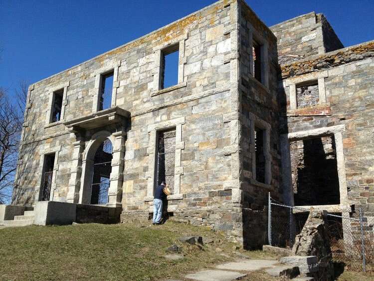
Goddard Mansion at Fort Williams Park in Cape Elizabeth was built for Civil War Union Army officer John Goddard.
Please do not leave this page until complete. This can take a few moments.
 Courtesy / Greater Portland Landmarks
Mechanics' Hall, on the corner of Congress and Casco streets in Portland, was designed in 1857 and is today suffering significant deterioration.
Courtesy / Greater Portland Landmarks
Mechanics' Hall, on the corner of Congress and Casco streets in Portland, was designed in 1857 and is today suffering significant deterioration.
Wrecking balls and a lack of maintenance are primary culprits in the selection this year of the Portland area's "Places in Peril" by Greater Portland Landmarks.
The nonprofit preservation group's list is designed to call attention to threats facing historically significant places in the region.
“These properties help define Greater Portland,” Sarah Hansen, Landmarks’ executive director, said in a news release. “In every case, the sites we’ve identified contribute to our community identity and help us interpret the stories of people who shaped the places we love.”
Landmarks calls attention to places in peril to build community awareness, advocate for the preservation, protection and, in some cases, adaptive-use of the properties, and convene people and resources.
This year, Landmarks identified five sites at critical risk of being permanently lost or diminished: Goddard Mansion, at Fort Williams Park in Cape Elizabeth; historic parts of the Portland neighborhood of Bayside; Gorham’s Corner in downtown Portland; Mechanics' Hall on Congress Street; and the Mountain Division railroad culverts in Westbrook and Windham.
Here's a look at the properties, as described by Greater Portland Landmarks. For more information, click here.
Located at Fort Williams Park in Cape Elizabeth, Goddard Mansion is of the few remaining works of Portland architect Charles A. Alexander. The mansion was built in the 1850s for Civil War Union Army officer John Goddard, who earned a considerable fortune in the lumber business before the war. Constructed of local Maine stone in the Italianate style, the home overlooks Casco Bay.
The mansion continued to operate as military housing through the 1920s, but was gradually abandoned. The mansion was seriously deteriorated upon the town’s acquisition of the property in 1962.
The mansion has been under threat of demolition since the early 1960s. In 1981, the interior of the building was burned in a controlled fire and removed.
Since 2009, the mansion has been surrounded with temporary fencing for public safety reasons. A recommendation for demolition, with a remaining commemorative plaque, has been favored by public boards, such as the Fort Williams Advisory Council. Opposition to demolition came from neighbors and property owners on Surf Road and by Greater Portland Landmarks.
In response to a 2015 townwide survey in which more than 50% of residents said they want the mansion stabilized, the Cape Elizabeth Town Council adopted a policy ensuring that the remaining structure would be maintained.
However, a 2021 draft park master plan proposes removing the side and rear wall, stabilizing just the front façade. While there is still support for saving the remaining mansion, funding needs to properly stabilize and maintain the structure have not been determined.
Agents of decay include wind, rain and frost, which can wash out mortar and erode structural masonry, leading to progressive collapse. Birds and animals can burrow into and undermine ruined walls, and woody vegetation will lever walls apart.
According to Landmarks, the best way to ensure a ruin is properly maintained is to make productive, and perhaps revenue-generating, use of it. Examples of successfully maintained ruins exist that have been reroofed and given new uses, and many more remain simply as monuments of history. They are often attractions of interest to historians, tourists, photographers and the general community. The mansion could provide a setting for events, summer theatre performances or musical concerts, or repurposed into a restaurant, cafe or overnight accommodations.
Dating back to the 1860s, Bayside is home to many of the earliest homes in Portland. During the mid-20th century Urban Renewal movement, Portland’s newly created Slum Clearance and Redevelopment Authority highlighted Bayside as a target neighborhood. In 1958, the Authority demolished well over 100 dwellings and small businesses in what is now called East Bayside. Another 54 dwelling units were razed for the Bayside Park urban renewal project, an area that now includes Fox Field and Kennedy Park public housing.
Razing of the Franklin Street area began in 1967, when 100 structures were demolished and an unknown number of families were relocated or displaced.

Long-term disinvestment in Bayside and the historic disenfranchisement of its immigrant communities has led to deferred maintenance on many historic properties or to their demolition, many due to neglect. Many buildings have been replaced with parking lots in the last several decades. Recent new development is being undertaken in the neighborhood.
The dispersal of social services to other locations in the city and the neighborhood’s proximity to downtown is facilitating the neighborhood’s transformation. Many successful rehabilitation projects, such as Schlotterbeck & Foss, Coffee By Design and Batson River Brewing & Distilling complement long-term businesses like Portland Architectural Salvage and new infill projects like Bayside Bowl and several new housing developments.
Two homes, located at 15 and 19 Cedar St., were nominated to the Places in Peril List in July. They were demolished in early August. There is currently no plan of what will happen with the two vacant lots. The houses represented Portland’s mid-19th century architectural history and Portland’s immigrant story.
Sharing the history of the Bayside neighborhood’s immigrant story, particularly places associated with the Armenian-American and Chinese-American communities in the early 20th century, is considered critical to understanding Portland’s history.
In downtown Portland, the Gorham’s Corner neighborhood is where Danforth, York, Pleasant, Union and Fore streets meet. It was a primarily Irish neighborhood beginning in the 1820s.
Named for early resident William Gorham, a grocer, it was a working-class neighborhood that gained a reputation as an unsavory part of town, known for its saloons and tenements.
Largely rebuilt west of Maple Street following Portland’s 1866 fire, it remained a predominantly Irish neighborhood well into the late 20th century.
Demolitions beginning in the 1970s reduced much of the historic neighborhood to parking lots, particularly west of Center Street. In the late 1980s, the threatened demolition of 505-509 Fore St., known as the Tracy-Causer Block, to provide a cleared development site, led Landmarks to advocate for a demolition delay ordinance, approved in 1989, which saved the building.

The individually landmarked Tracy-Causer Building is now a bridge between the Old Port and the Gorham’s Corner neighborhood. The fate of two buildings between Cotton and Center streets is uncertain. The vacant former Brian Boru building is proposed for demolition.
According to Landmarks, there remains a need to halt demolitions that result in only surface parking, not redevelopment, in Downtown Portland.
Beyond historic and cultural reasons, the practice is considered to cause environmental implications with regard to landfilling demolished buildings, and increased run-off and “heat island” effects of surface parking.
Mechanics' Hall, on the corner of Congress and Casco streets in Portland was designed in 1857 by Portland architect Thomas J. Sparrow and purpose built for the Maine Charitable Mechanics Association to house its library and create a communal gathering space for Portland’s creative community.
Mechanics’ Hall remains the property of the association, which rents out storefronts on the ground floor, maintains its membership library, and hosts events in the building. It is one of the few surviving buildings designed by Sparrow, and is a well-preserved example of mid-19th century Italianate architecture. Featuring a granite façade with tall, arched windows extending between the second and third floors, additional high clerestory windows jut out from a low hipped roof. The windows on the façade are punctuated by keystones depicting the faces of Vulcan and Archimedes, as well as the association’s chief symbol, a stylized arm with a hammer.

The most pressing threat facing Mechanics’ Hall is the deterioration of the structure’s clerestory roof. Due to gradual weathering, the condition of the roof now constitutes a serious threat to the building’s structural integrity. Mechanics’ Hall’s problems have been compounded by the stopgap nature of maintenance periodically undertaken throughout the history of the organization, which has never possessed the capital to properly address them. The association is running out of time to act, as waiting any longer threatens to deepen existing structural issues as well as create new ones that would jeopardize the building’s continued survival.
The building’s structural issues are addressable, but require a large capital investment. The association is looking into drawing on various sources of funding, including federal grants, but the application and approval process can take years. Given the condition of the clerestory, urgent action from individual donors and the community as a whole is necessary.
Mountain Division railroad culverts in Westbrook and Windham are part of the Portland and Ogdensburg Railroad, chartered in Maine in 1867 with construction starting in 1869. By the early part of the 20th century, the expanding Maine Central Railroad absorbed the P&O RR between Portland and St. Johnsbury, Vt., together with a line branching north from Whitefield, N.H., running deep into Quebec.
Passenger service on the scenic run ended in 1958, and freight trains stopped rolling after Guilford Transportation (later Pan Am Railways) acquired it in the 1980s.
Stone culverts along the Mountain Division line are of two primary styles, arched culverts and boxed culverts. Arched culverts, in both function and appearance, are small stone arch bridges while box culverts have vertical stone walls that support a large stone slab that spans the opening width.
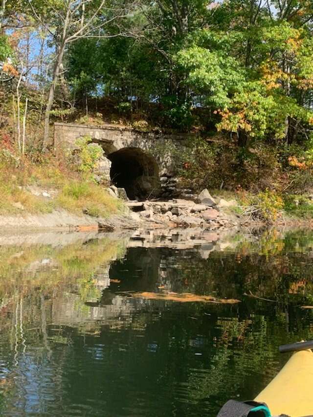
Inactivity along the railroad corridor has led to deteriorating condition of many of the historic stone culverts that span tributaries to the Presumpscot River.
Local and statewide interest in restoration of the Mountain Division led the Maine Department of Transportation in 2007 to evaluate the condition and potential passenger and freight rail uses of the 50-mile Mountain Division rail line in southern and western Maine. The study identified several stone box and arch culverts on the lower sections of the rail tine in need of repair, cleaning and debris removal. Long-range plans, supported by the Mountain Division Alliance, call for a continuous 50-mile trail from Portland to New Hampshire along the Mountain Division corridor in collaboration with the nine communities along the line.
A feasibility study for the concept is currently being conducted by Maine Department of Transportation, Department of Economic and Community Development and the Governor’s Office of Policy, Innovation and the Future.
Funding for this particular corridor is not imminent. In the meantime, the stone culverts between South Windham and Westbrook continue to deteriorate.
Landmarks said it will continue to monitor the endangered properties in hopes that they can be removed from the list in the near future. Landmarks’ intention is to proactively work with property owners as much as possible to protect the properties for the future.
Since its first list in 2012, Landmarks has assigned Place in Peril status to 35 places and issues. As of this year, seven are considered protected or saved, and seven others have made progress toward preservation. Places in Peril is the only endangered properties program in Maine which focuses on a local region. There are approximately 60 such statewide and local programs in the United States.


0 Comments