
Courtesy / The Nature Conservancy
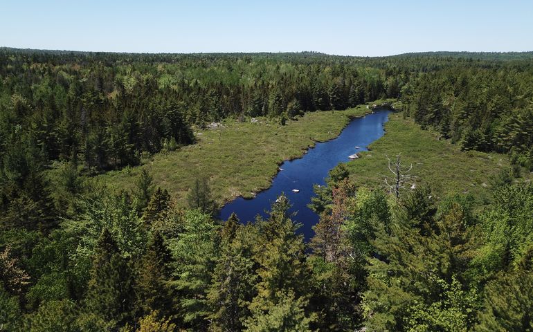
The Spring River–Narraguagus Forest expands the Nature Conservancy’s 9,700-acre Spring River Preserve.
Please do not leave this page until complete. This can take a few moments.
 Courtesy / Tom Pakulski
The Nature Conservancy acquired 13,500 acres west of Cherryfield considered important for wildlife passage and ecosystem sustainability. Seen here is Macomber Mill Stream, part of the newly protected area.
Courtesy / Tom Pakulski
The Nature Conservancy acquired 13,500 acres west of Cherryfield considered important for wildlife passage and ecosystem sustainability. Seen here is Macomber Mill Stream, part of the newly protected area.
A new conservation protection project in Hancock County is expected to provide both environmental and economic benefits to the region.
The Nature Conservancy in Maine announced Thursday it acquired a 13,500-acre property called the Spring River–Narraguagus Forest, west of Cherryfield.
The land is part of the traditional territory of Wabanaki people and retain cultural significance to the Wabanaki today.
The acquisition completes a collaboration between the Conservation Fund, Nature Conservancy, Maine Coast Heritage Trust, New England Forestry Foundation, Blue Hill Heritage Trust, and Downeast Salmon Federation. With this acquisition, the effort has conserved more than 17,000 acres of forestland to protect wildlife habitat, ensure future recreational access and support the economies of nearby coastal communities.
“This work improves fish passage and the quality of the land along the shore, creates more recreational opportunities and restores ecosystems critical to the sustainability of Maine’s fishing industry — all part of our efforts to create resilience in the face of climate change,” Tim Glidden, president of Maine Coast Heritage Trust, said in a news release.
The property will be open to people to access for uses such as birding, hunting and fishing, although there is limited recreational infrastructure, roads are seasonal, and overnight camping and pets are not permitted.
Conservation is expected to help maintain a forested connection between the Downeast coast and Maine's north woods, protecting habitat for wildlife and allowing species to move in response to a changing climate.
The property includes 3.75 miles of shoreline on Narraguagus Lake, nearly completing conservation of the shoreline of the headwater lake for Spring River, as well as two miles of frontage on the north side of Spring River, seven miles of frontage on the West Branch of the Narraguagus River, and 46 miles of interior tributary streams.
The acquisition expands the conservancy’s 9,700-acre Spring River Preserve, which was acquired in 2005, to 23,500 acres.
The conservancy intends to manage a majority of the forest as an ecological reserve.
The Spring River Preserve also abuts an ecological reserve maintained by the Maine Bureau of Parks and Lands on a portion of the Donnell Pond Unit of Public Reserved Lands.
“This announcement is important news for biodiversity in the face of a changing climate,” Mark Berry, the conservancy’s forest program director for Maine, said in the release. “It expands an ecological reserve to a size that can support the movement of plants and animals, helping maintain a critical pathway for species to move across the landscape between the Downeast coast and northern Maine. It will also benefit important aquatic habitat in the Narraguagus River watershed.”
The reserve is also expected to be important to scientists studying the growth of forests and how they respond, in the absence of timber harvesting, to challenges such as climate change, forest pests, diseases and airborne pollution.
The acquisition is part of a larger strategy by the conservancy to address the effects of climate change through conservation. Wildlife species in North America are shifting their ranges an average of 11 miles north and 36 feet in elevation each decade. Many species are approaching, or have already reached, the limit of where they can go to find hospitable climates. Research by the conservancy and partners shows that nearly 60% of U.S. lands and waters are fragmented by human development, preventing species from finding new and more hospitable habitat.
The conservancy has used science to identify a network of places across the U.S. that can withstand climate impacts and provide safe havens where species can live and thrive. Safe havens contain features such as steep slopes, diverse soil types and wetlands. The conservancy has mapped connected ecosystems that are expected to be important for the movement of plants and animals as climate change alters the landscape. The analysis is a primary driver of the conservancy’s land conservation efforts.
The acquisition completes a collaboration between the Conservation Fund, Nature Conservancy, Maine Coast Heritage Trust, New England Forestry Foundation, Blue Hill Heritage Trust, and Downeast Salmon Federation that now has conserved more than 17,000 acres of forestland to protect wildlife habitat, ensure future recreational access, and support the economies of nearby coastal communities.
The partners received federal grants for the purchases through the Land and Water Conservation Fund and the North American Wetland Conservation Act.

The Giving Guide helps nonprofits have the opportunity to showcase and differentiate their organizations so that businesses better understand how they can contribute to a nonprofit’s mission and work.
Learn More
Work for ME is a workforce development tool to help Maine’s employers target Maine’s emerging workforce. Work for ME highlights each industry, its impact on Maine’s economy, the jobs available to entry-level workers, the training and education needed to get a career started.
Learn More
Whether you’re a developer, financer, architect, or industry enthusiast, Groundbreaking Maine is crafted to be your go-to source for valuable insights in Maine’s real estate and construction community.
Learn moreThe Giving Guide helps nonprofits have the opportunity to showcase and differentiate their organizations so that businesses better understand how they can contribute to a nonprofit’s mission and work.
Work for ME is a workforce development tool to help Maine’s employers target Maine’s emerging workforce. Work for ME highlights each industry, its impact on Maine’s economy, the jobs available to entry-level workers, the training and education needed to get a career started.
Whether you’re a developer, financer, architect, or industry enthusiast, Groundbreaking Maine is crafted to be your go-to source for valuable insights in Maine’s real estate and construction community.
In order to use this feature, we need some information from you. You can also login or register for a free account.
By clicking submit you are agreeing to our cookie usage and Privacy Policy
Already have an account? Login
Already have an account? Login
Want to create an account? Register
In order to use this feature, we need some information from you. You can also login or register for a free account.
By clicking submit you are agreeing to our cookie usage and Privacy Policy
Already have an account? Login
Already have an account? Login
Want to create an account? Register
This website uses cookies to ensure you get the best experience on our website. Our privacy policy
To ensure the best experience on our website, articles cannot be read without allowing cookies. Please allow cookies to continue reading. Our privacy policy


0 Comments